We Can Build A Better, Safer Road
The way we used to design roads is killing us and making it dangerous for kids to walk & bike to school. We can change that.
The way we used to design roads is killing us and making it dangerous for kids to walk & bike to school. We can change that.
The City of Madison has been improving roads for years now and is planning some great changes in the new West Area Plan that will improve safety, let’s support these efforts.
If you don’t live in Madison, we generated a map of where drivers of cars are hitting kids near every public school in Wisconsin. You can download the map for a school near you and follow along with the article to find out how to help your community.
Part 1: What is the problem?
On November 18th, 2021 at lunchtime on a clear day, a 14-year old boy was crossing the street in front of his school in a crosswalk when a driver hit him and sent him to the hospital. Another pedestrian had been hit on that same stretch of road in August, two more would be hit later that year in November and December, three more pedestrians would be hit there in 2022, two more pedestrians in 2023 – all on the same road and all entirely preventable.
Car crashes have been the number one cause of death for school-aged kids in Wisconsin in recent decades. Like any complex issue, stopping drivers from hitting kids requires a multi-pronged approach, which the Wisconsin DOT calls Safe Systems. In this case, the driver should have stopped for the flashing pedestrian lights at a crosswalk and the child could have made sure all traffic was stopped before crossing. At the Bike Fed, we work to educate kids and drivers, but changing human behavior is difficult and takes time.
In the education world there’s a saying: when a student fails a test, it’s the student’s responsibility; when the whole class fails a test, it’s the teacher’s responsibility. The same is true here. We can work to change driver and pedestrian behavior, but when drivers keep hitting kids on the same stretch of road, it’s time to design a better road.
The road we’re talking about is Gammon Road, which runs next to Vel Phillips Memorial High School and Ezekiel Gillespie Middle School in Madison, WI. The school has approximately 2000 students and is an average Madison school in terms of wealth and racial makeup. Here’s a map that marks where drivers have hit kids near Memorial High School over the last 7 years:
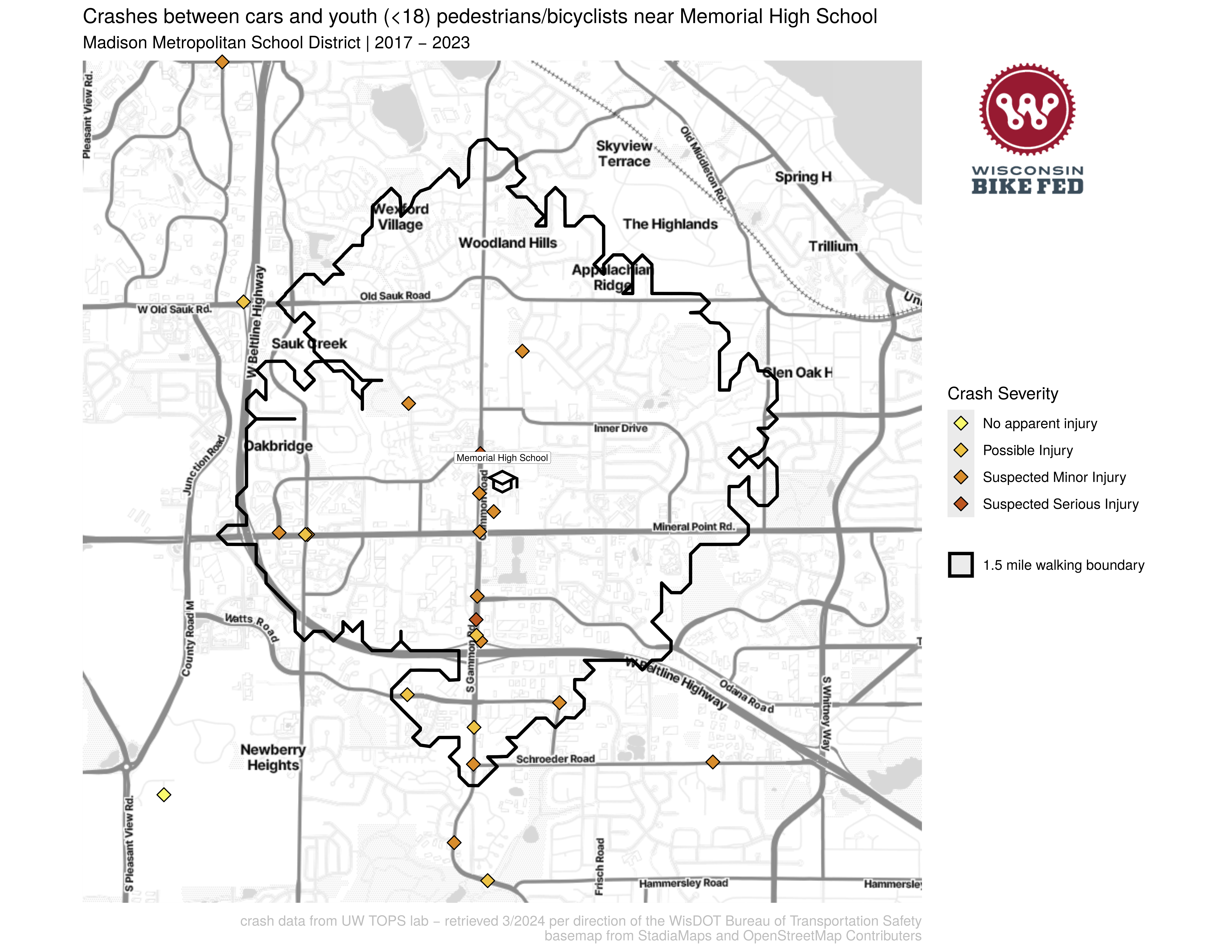
The bold black line encircling the school represents a 1.5 mile “walk boundary” within which Madison’s school district doesn’t provide bus service and expects students to walk, bike, or find private rides to school. This district policy is in part because of state funding for school transportation in Wisconsin that only funds bus service to students who live farther than 2 miles from their school.
Looking at this map, a cluster of crashes jumps out: the road that runs North-South directly adjacent to the school. That North-South road is Gammon Road, and it’s the place where the 14-year old was hit in 2021 in front of their school. It’s where drivers have hit 12 kids walking or biking in the last 7 years.
Many of these students live south of the Beltline and walk along Gammon Road to get school and many students live Northwest of the school and have to cross Gammon Road to get to school. Children across the street from the Lussier Community Education Center need to cross 6 lanes of vehicle traffic to access the center.
Stroads
Gammon Road is a typical, dangerous stroad. No, that’s not a typo: a stroad is a relatively new term coined by Strong Towns in 2011. A stroad is the ugly hybrid between a road (a high speed thoroughfare between two places) and a street (a destination with shops, schools, homes, etc. that people interact with). This video from Not Just Bikes does a great job illustrating what a stroad is:
Stroads are dangerous. They combine multi lane high speed traffic traveling through the area and people trying to use the amenities in the area. Gammon Rd is 4-6 lanes wide and has a high school, a middle school, a community center, and a mall on it. Some people use Gammon Road to drive through the area, some people are going to the schools or shops or home along it. These uses are in conflict with each other and make it impossible to optimize the road design for both. In this case, decades ago, the road designers decided to prioritize faster through-traffic over the people going to the places along the road (like kids walking to school). This design fails both groups: drivers traveling through an area are often slowed by people stopping to drop off kids at school or going to the mall, and those trying to use the area find themselves in an environment hostile to walking, bicycling, or riding the bus.
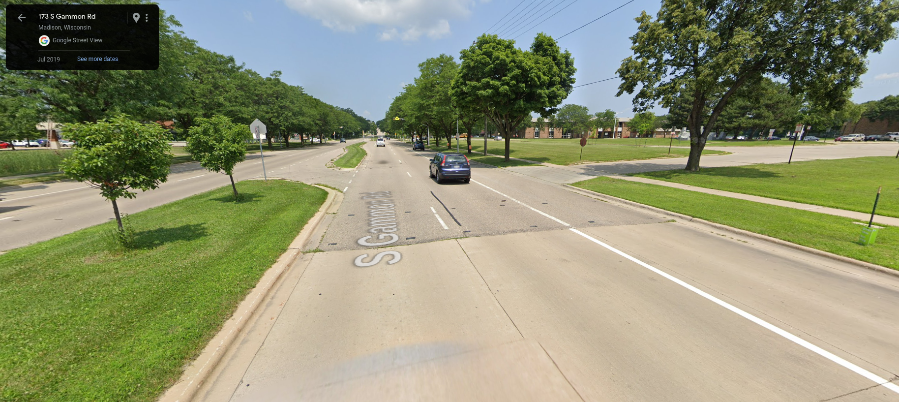
Here’s an image from Google Street View of Gammon Road, showing the 6 lanes of car traffic next to shops:
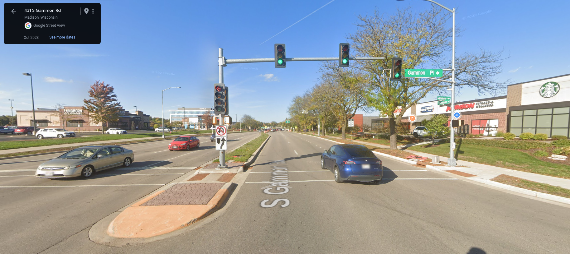
And Gammon Road next to a Memorial High School (on the right):
So what can we do to make Gammon Road safer? We can follow the successful example of the city of Madison transforming North Sherman Avenue on Madison’s north side.
Part 2: How can we fix this?
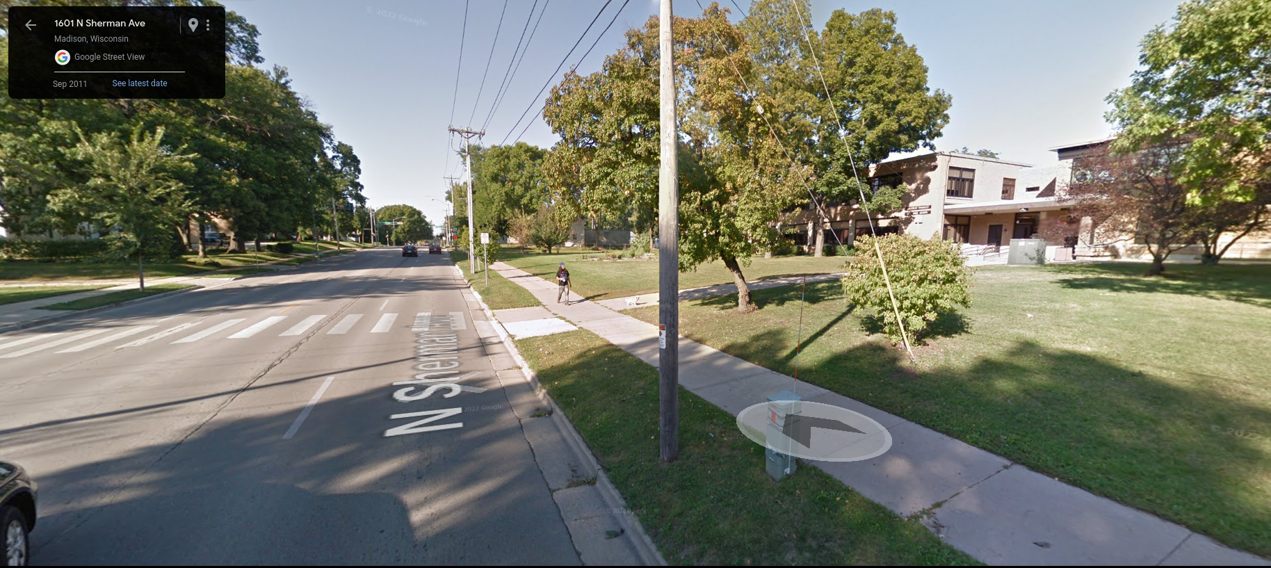
In 2011, North Sherman Ave was a four lane stroad lined with businesses, homes, Sherman Middle School, and Shabazz High School: car traffic was fast, and drivers were hitting kids. Here’s what it used to look like in 2011 (Sherman Middle School is on the right).
The city had been aware of these issues for decades and in 2009, as part of the local neighborhood plan, started looking into options to make it safer. In 2012, the city proposed turning the four lanes of car traffic (two in each direction) into three lanes of car traffic (one in each direction plus a middle turning lane) and a bike lane. They also proposed adding pedestrian islands along the way at key crosswalks (like in front of the middle school pictured above). Residents and businesses pushed back quite hard on this idea. Residents feared fewer car lanes would mean car congestion on Sherman and car traffic diverted to side streets. Some business owners thought people would stop driving in front of their shop and business would dry up.
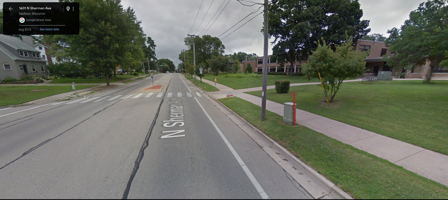
In 2013, the city moved the redesign forward, changing the street from four car lanes to three, adding pedestrian islands and bike lanes. It’s a pretty subtle change, this is what North Sherman Ave looks like now at that same location (the middle and high schools are on the right):
The City also collected data to measure the impacts of the changes. You can read the report from the city for all the details, but here is a summary of what happened.
Results of North Sherman Ave redesign:
- Very little change in the number of cars on either N Sherman or side streets.
- Drivers slowed down: before the redesign 85% of cars were under 36.5mph, afterward 85% were under 34.4mph. Slower speeds means that when crashes do occur, they are far less deadly.
- Crashes dropped from an average of 25 per year to 11 per year.
- Before the redesign, 41% of crashes resulted in someone injured, afterward, only 11% of crashes resulted in injuries. Reducing the crash rate and injury rate means that the road went from injuring 11 people per year to injuring 1 person per year!
- Bicycling increased by 40%, showing that the best way to encourage bicycling (with all its accompanying benefits) is to make our built environment safer and more comfortable for all users.
And the shops and restaurants that were worried about business drying up? Well, it’s hard to find business revenue data, but there are certainly a lot of new businesses that are opening on that stretch of North Sherman. Research shows that replacing car infrastructure (car lanes and street parking) with pedestrian and bike infrastructure is usually quite beneficial for local businesses.
Part 3: What can we do now?
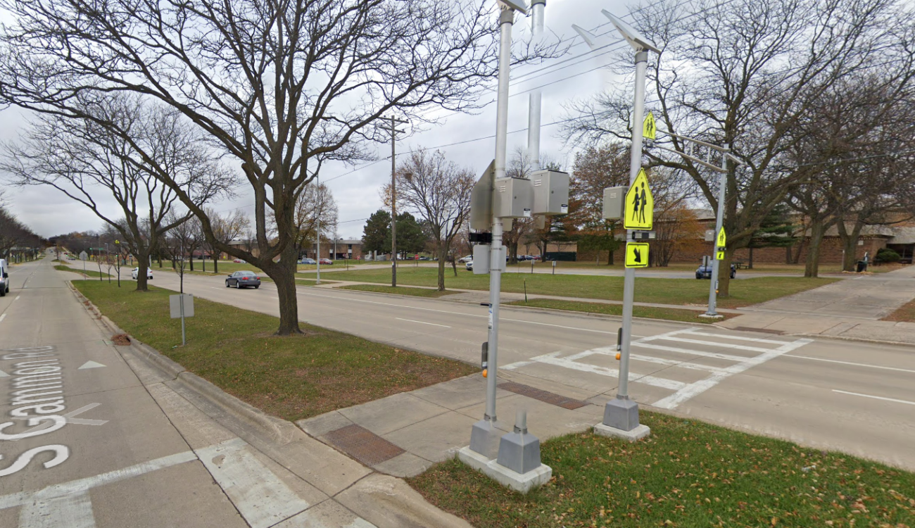
Back to Memorial High School and Gammon Road, what can we do here? Well, the city actually improved the situation in 2020: they added a bike path that runs adjacent to part of Gammon Road and added warning lights at select pedestrian crossings. This is the spot where the 14-year old boy was hit in 2021, after those improvements:
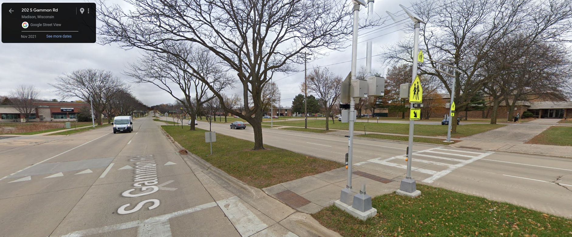
He crossed in the crosswalk from the west (left) side of Gammon Rd to the east, where Memorial High School can be seen. He pressed the button that activated the new flashing lights and crossed three lanes to the center pedestrian refuge island. As he crossed the second set of three lanes, a minivan in the close northbound lane stopped for him; a car in the second lane saw the flashing lights and the stopped minivan, but didn’t see the kid; so the driver kept going, hitting the child as he stepped out into the second lane.
Adding pedestrian lights (called RRFBs) can be helpful, but it is only a partial solution – the kid activated the lights and was still hit. The real issue here is multiple car lanes and high speed traffic. If we reduce the car lanes like the city did on North Sherman Ave, we would see fewer children getting hit. This is exactly what the city is proposing in their West Area Plan.
When developing this plan, the city planners met with students from Memorial High School to learn what students were experiencing while walking & bicycling to school. We are working to continue to involve those students with the planning process. Unfortunately, this plan has been met with the same backlash the Sherman Ave redesign faced by some vocal residents.
Now reducing the car lanes on a road has other implications besides improving pedestrian safety, and I’m not going to pretend to be a traffic engineer. The City of Madison is full of excellent traffic engineers and city planners who are very good at modeling how street design impacts safety, traffic, development, and behavior. What we can do to help is show our support for road diets and other traffic calming measures at public meetings and in comments to the city. If the only people that show up to the meetings are those content with the status quo and opposed to change, cars will keep hitting kids in the same places. We can change that.
The City of Madison’s West Area Plan improves pedestrian and bicycle safety, particularly around schools. If you live or work in Madison, tell the city you support efforts to redesign roads to prioritize safety for pedestrians & bicyclists.
Update: The City of Madison Common Council unanimously adopted the West and Northeast Area Plan on September 10th, 2024!
Improvements Statewide
Here at the Wisconsin Bike Fed, we hope to help communities statewide improve their bike infrastructure. To that end, we’ve generated a map where cars are hitting kids near every school in the state. We hope this is a useful tool for people advocating for safer streets in their communities. Please feel free to download and print and distribute these as you see fit!
Here are those maps organized by county and school district:
As you look through these maps, you’ll notice that many of the worst designed roads are often state highways. This makes them more difficult to redesign as the local municipality and the state DOT need to collaborate and navigate both levels of red tape. Marybeth McGinnis, our MilWALKee Walks Manager, wrote about the issue with the National Ave redesign in Milwaukee. Milwaukee (in collaboration with the Wisconsin DOT) seems poised to go through with a bike and pedestrian friendly redesign! It is possible to change state highways.
If you’re interested in looking at car crashes more broadly (not just where kids are hit while walking/biking), here’s the TOPS lab’s interactive map.
Have questions or thoughts after reading this article?
(particularly if you’re a student or family member of a student at one of the schools in the area discussed)
Please reach out to Ben Varick, Bike Fed’s Dane County High School Education Manager, at ben@wisconsinbikefed.org.