Chasing Waterfalls and Stormy Kromer
Head to the gravel roads somewhere north of Highway 8 where cell service is spotty.
Even before TLC popularized the phrase in modern culture, people have been warning me about chasing waterfalls and tilting at windmills. While my tally of failures may outnumber successes, the rewards have been worth it overall.
When you work in bicycling, weekends don’t necessarily equate to time off and with text messages and email notifications, I can’t necessarily get away from work on a bike ride. When I really want to get away, I typically head to the gravel roads somewhere north of Highway 8 where cell service is spotty. Getting away from phone calls, text messages, email and social media helps me feel re-energized. Getting lost in nature once in a while and being forced to change your plans helps put work failures in perspective too.
Perhaps because Mother Nature makes no promises, when you do see a bear, elk, eagle, or run across an unexpected waterfall, it feels all the more rewarding.
I have been bicycling and hunting along the gravel fire lanes and logging roads of Northern Wisconsin for more years than I like to remember. In those travels, I have heard about far more waterfalls than I have stumbled across. So I decided to do some advance research, draw some lines, drop some POIs in RideWithGPS, and plan a trip to find as many waterfalls as I could in a weekend bikepacking trip.
The 114-mile route I planned on RideWithGPS would pass by 10 waterfalls, most of which I had never visited. Because I knew there was going to be some bushwhacking and exploring to find these waterfalls, I planned to take three days to do the loop.
Arrival Day: About 15 miles
- Drive to Upson, set up camp next to Upson Falls, then ride to Rouse Falls and try to find Little Balsam Falls if we can. This will give you a amuse bouche size taste of Northwoods bushwhacking.
Day One: 51 miles
- Morning: Break camp, ride northeast and visit Spring Camp Falls, Gile Falls, and stop at the Stormy Kromer factory
- Lunch: Grab a pasty
- Afternoon: Stop by Petersen and International Falls on the way out of town and bike to Potato River Falls.
- Evening: Camp at Potato River Falls campground
Day Two: 63 miles
- Morning break camp, bike to Foster Falls, Wren Falls, and Copper River Falls
- Lunch: Grab food in Mellen
- Afternoon: Ride gravel roads back to Upson where we left the Sprinter van
- Evening: Drive back to Milwaukee
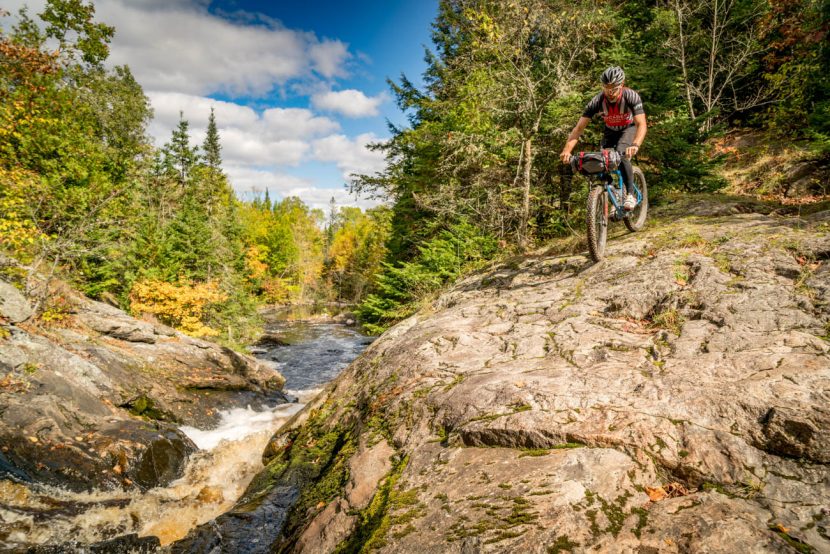
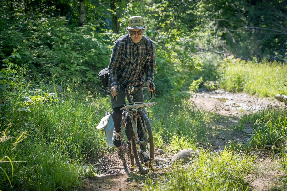
My default bike of choice for riding Northwoods gravel with the occasional mountain bike or ATV trail thrown in is my Fyxation Crusher carbon adventure bike. This trip I was excited be testing a new prototype carbon fork, with double mounts, headlight mount and internal dynamo wire routing. I run a Shutter Precision dynamo hub and a Sinewave Beacon headlight, which has an output to keep my phone charged, which I use to keep on the route I download from RideWithGPS.
I was able to mount Salsa Anything Cages to the front fork, dramatically increasing the bikes load carrying capacity and allowing for better weight distribution. My set-up for this trip was:
- Front Fork/Anything Cages: Zpack Soloplex tent on one side and Jetboil stove and coffee grounds on the other.
- Revelate Terrapin Seat Bag: Sea to Summit Silk sleeping bag liner, clothes, toiletries, Good to Go dehydrated meals (yummy!), and Oatmeal.
- Revelate Tangle frame bag: tent poles, spare tube, spare camera batteries, memory cards, Joby Gorillapod tripod, lighter and Topeak Alien Multitool.
- Ortleib Ultimate 6S Plus Handlebar Bag: Sony A7III camera with 24-105 F4, Mammut rain jacket, phone in top map area running route.
- Two Revelate Mountain Feedbags: Sony 70-200 in one, water bottle, Bonk Breaker bar and jerky in the other.
- Three water bottle cages: two water bottles, one Nalgene bottle with Soulboxer Brandy Old Fashioneds
On trips like this where I know I am going to be doing a lot of hiking, I run Fyxation Mesa MP platform pedals and Fiveten Freerider Contact shoes, which are super grippy and saves me bringing a second pair of camp shoes. Regular shoes also make bushwacking more bearable, and the sticky rubber on the Fivetens gives added confidence climbing wet rocks around waterfalls.
My partner in crime for this adventure was Peter DiAntoni, a great photographer and the designer for this magazine. Pete has been on plenty of these exploratory trips with me in the past, so he had become comfortable rolling with me when I only have a 70% confidence I know where I am going at any point on the trip. Pete’s bike of choice was his very capable Milwaukee Bicycle Company Fugitive fitted with a stout front rack made by Jordan at Third Coast Bikes Works.
Day One
The drive up to the small town of Upson was uneventful. We did stop at Joe’s Pasty Shop in Ironwood on the way to pick up lunch. We got there too late to try an elk or camel pasty, both were sold out by 2pm when we walked in. Luckily they still had traditionals hot and ready to go. They smelled great which made it hard to wait, but we stuffed them in our packs to eat when we got to Upson Falls, just 13 miles down the road.
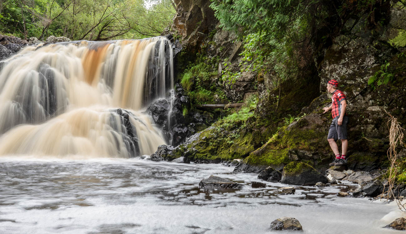
The Upson Falls Campground is small, but very nice and right next to the falls. We quickly set up our tents, grabbed the pasties and hiked down to the Upson Falls on the Potato River to eat a late lunch. These are probably the easiest falls to access on the entire route, so it made a great place to start.
UPSON FALLS (N46.37009, W90.41133)
After a quick lunch and some photos, we hopped on the bikes and headed off to find Rouse Falls and Little Balsam Falls. Finding Rouse Falls proved very easy. A short ride down 77, which has 3 ft paved shoulders, we headed north about a mile on Casey Sag Road (gravel) and looked for the Rouse Falls sign. Then we rode half a mile west until the unimproved gravel road dead ends into a trail. We were able to ride our bikes in another couple hundred yards, but then had to get off and hike/bushwack our way the last 50 yards to Rouse Creek and the falls.
ROUSE FALLS (N46.36843, W90.47791)
After some photos, we got back on our bikes and headed off in search of Little Balsam Falls. We rode west on 77 about a mile, then turned north onto Jacks Road (gravel) for a quarter mile when it turns into two track. We followed that for another quarter mile where it ended at a large metal gate marked “No Trespassing Violators Will Be Prosecuted.” Disappointed, we backtracked and rode a little further west on 77 where we found a very overgrown two track. I told Pete to wait while I tried riding north into the woods. As I pedaled, the ground got softer and wetter until it turned into mud. I turned around and told Pete this one was no go.
We headed back to Upson, where by chance there appeared to be a meeting going at the town hall because there were two cars and a four wheeler parked outside. I apologized for interrupting their meeting and asked how to get to Little Balsam Falls, but nobody there had ever heard of it. I was able to get approval to leave our van parked behind the town hall overnight the next day when Peter and I headed off on the big loop though, so it was not a total loss.
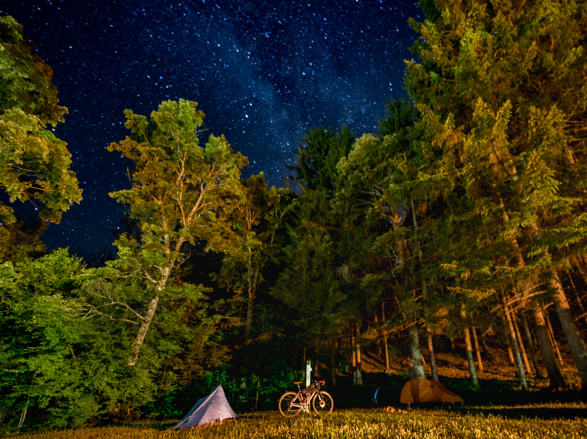
Pete and I headed back to camp, sat by the fire and drank a couple beers we brought along and agreed Little Balsam Falls would have to wait for another trip. After dark the Milky Way was out in full force, so both Pete and I set up our cameras on tripods for long exposures before we went to bed.
Day Two
With quite a bit of riding on untested roads and potential bushwacking to waterfalls ahead of us, we were both anxious to hit the road early, so we munched on some bars, broke down camp, packed our bags, parked the van and headed off without making coffee. Our first stop was to be Spring Camp Falls, only a short 15 miles away.
We pedaled south out of Upson on O’Brien Road (gravel) to what RideWithGPS showed as Track Road. When we got to Track Road, it was rutted, washed out and really rough looking, but rideable, so off we went. After a steep, loose climb, the two track turned to a grassy trail with lots of deadfall we had to hike around and under. It got thicker and thicker until I came across a hunting stand surrounded by large paw prints, always both exciting and a little unnerving at the same time.
We pushed on, but the trail did not seem to be heading in the right direction and RideWithGPS kept warning me I was off course. After an hour of some riding and lots of bushwhacking, we ended having done a lollipop of a route back on the two track where we started. So we headed back down to O’Brien Road and continued onto Norman Road, rough, but very rideable gravel.
We took Norman to Snake Trail Road, when my confidence level in the route jumped to 100%. I had ridden on Snake Trail Road on a previous bikepacking trip from my deer hunting camp in Peeksville to visit Spring Camp Falls with my hunting buddy Casey, so I knew the rest of the way.
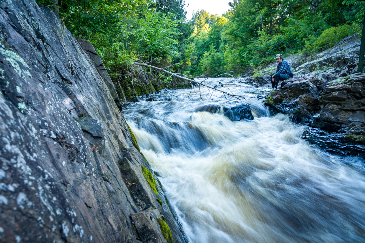
You can get to Spring Camp Falls from the west side of the Montreal River on Spring Camp Road. From the east side of the river you take Island Lake Road to Falls Road. There is a short hike-a-bike in from both sides, but it is worth it. You can actually ride a little bit on the rocks around the falls.
SPRING CAMP FALLS (N46.34833, W90.23886)
Because our lollipop bushwacking misadventure ate up a lot of time and since I already had nice photos from Spring Camp Falls, Pete and I decided to skip these falls and head directly north into Montreal to find the Gile Falls, which Casey and I were unable to find on that last trip.
We got into Montreal and began our search for Gile Falls. This time we were successful in finding the falls. There are two ways to access the falls. From Montreal, ride into the parking lot of the Montreal Public Works on the south side of 77, across from Plant Street and the little park. Keep going to the southeast corner of the parking lot toward the mine tailings hill where there is a hiking/cross country ski trail. Follow this trail and it will take you to a bridge just above the falls. This trail skirts one of the impressive man made hills created during the mining era.
You can also access Gile Falls by heading south off 77 into the town of Gile on Kokogan Street, then onto Mellon Street, which dead ends into a trail that leads to the Montreal River and the same bridge over the falls. A short distance south of the falls, there is a dam on the Montreal River that creates the Gile Flowage, which was created back in the logging days to float logs down stream. The Gile Flowage is awesome smallmouth bass fishing, but Pete and I didn’t have time this trip to cast a line.
Many of the little houses in Montreal that you can see along 77 have historic designations because they were built by the Montreal Mining Company beginning in 1907 to retain workers., which had several copper and iron ore mines in the area.
GILE FALLS (N46.43074, W90.22715)
After Gile Falls we rode north into Ironwood for a stop at the Stormy Kromer factory. Stormy Kromer hats are ubiquitous in the Northwoods. I’ll leave it to you to look up the interesting history. I will say that I have a special affinity for them because they were made in Milwaukee until 2001 when Bob Jacquart heard they might go out of business so he bought the company, moved production to his factory at Jacquart Fabric Products in Ironwood, Michigan. I even have a cool Stormy Kromer jersey and cycling cap. It turns out Bob Jacquart is an avid cyclist and friend of Chris Jackson, who owns Borah Teamwear in Coon Valley, WI.

After making coffee under the big hat outside the SK factory outlet store to wait out the rain shower, Peter and I continued our trip over to Peterson and Interstate Falls on the east fork of the Montreal River, which runs right along the Wisconsin/Michigan border. You have to ride about 3 miles on US Highway 2 past the Highway 51 off and on ramps. This is not super pleasant, but it is not far, and HWY 2 does have wide paved shoulders. Just past the off ramp, turn right on Center Drive by the sign that says Peterson Falls.
You can ride your bike on the trails right up to the viewing area for the falls.
INTERSTATE FALLS (N46.47552, W90.20085)
PETERSON FALLS (N46.47555, W90.20069)
After a bunch of photos, Pete and I continued our ride west on Center Drive (gravel) in search of Foster Falls. The deer flies followed us in a cloud around our heads and they seemed to think DEET was a marinade. We rode in long sleeves and full finger gloves, which kept them off us for the most part.
By the time we got to Saxon, it was 2 pm, and we were getting pretty hungry so we stopped for burgers, air conditioning, and a respite from the flies at the Saxon Pub. The burgers and fried onions were great, as was the bottomless glass of ice-cold Pepsi on a hot, dusty ride. We were able to get wifi while eating, and it looked like we were in for a storm tonight and the following day. Pete and I discussed cutting our trip short.
Looking at the map, we change our route and take Hoyt Road south out of Saxon and still see to Foster Falls. That route would also take us within 10 miles of Upson. Depending on how long it took us to find Foster Falls and take photos, we could either return to Upson or keep going on our route and ride the next day in the rain.
It turned out that Foster Falls were super easy to find as there was another sign at the gravel road to the falls. On the map the road to Foster Falls is marked at Sullivan, but there wasn’t a road sign I could see when we were there. The road to the falls switches between gravel and a little two track and ends at a small gravel parking lot. There is a trail you can ride to within 50 feet of the falls.
Foster Falls drops about 15 feet into a large pool and were quite impressive. I decided to call it a day after these falls, so I spent some time cooling off in the cool water of the Potato River. You can’t see under the mineral colored water of the pool, but there are lots of large granite boulders, so don’t jump in. I was able to slide into the river and make my way around the pool by navigating over the rocks by feel with my bare feet.
After an hour or so of refreshing in the cool waters, we got out and the heat dried us off in minutes. We kitted back up, put on our shoes and rode the rest of the hilly gravel route back to Upson where the Bike Fed Sprinter Van waited for us.
I was not disappointed at only doing half the planned route, because we had a great trip, saw half a dozen beautiful waterfalls and made a bunch of nice photos. It was a lot of fun, so both Peter and I are itching to head back to finish the trip. Speaking of itching, we might do it later in the fall when the cold temperatures at least slow down the deer flies and mosquitos.
- Ten waterfalls!
- Historic mining town of Montreal, WI or the “City Beautiful”, as it has come to be known, was built and maintained by the Montreal Mining Company within walking distance of the Main Shaft. Thel white “mining company” homes built for the miners and their families range from 2 and 3 story bedroom homes for the “captains and foremen” to smaller single story bungalows for the workers. Many of these houses are still standing and have been included in the National Register of Historic Places under the name of The Montreal Company location Historic District. Water and sewer systems were also provided, again by the mining company. The Montreal Mine closed in 1962 after approximately 100 years of operation. The miners dug to a depth of 4335 ft below the surface. Forty five million tons of ore were shipped during this period. The main shaft has since filled with water. An overflow from this shaft flows crystal clear water directly into the Montreal River. Tailing piles still loom over the site that housed the Mining Offices and Doctors Clinic.
- Stormy Kromer Factory Tour, Iconic Northwoods head gear, still made in the USA and the company is owned by an avid cyclist. 238 Wall St, Ironwood, MI 49938 (906) 932-1339
- Lispke’s Bar, 9382 W Hwy 77, Upson WI, 54565
- Luoma’s Saxon Pub, Wisconsin 122 Trunk, Saxon, WI (715) 893-2228 Has good burgers, sandwiches, wraps, pizza and bar snacks.
- Joany’s Sidekicks, 7833 W State Highway 77, Iron Belt, Wisconsin (715) 561-5515 Good pizza and other from scratch food, and the owner Joany is very nice.
- Cold Iron Brewing, 104 S Lowell St, Ironwood, MI 49938 (906) 285-7020 Greal craft beer in a fun environment.
- Joe’s Pasty Shop, 116 W Aurora St, Ironwood, MI 49938 (906) 932-4412 Amazing from-scratch pasty’s for $5-$7 make great bikepacking food. Always has a special flavor of the day, but they run out!
- Upson Falls Campground, 564 Upson Park Rd, Upson, WI 54565
An inexpensive small local campground located right on Upson Falls along the Potato River. We asked at the town hall and got permission to leave our car behind the building while we were gone riding. You might also ask to leave your car at Lipske’s Bar or Joany’s Sidekicks.