
Route of the Badger: Slow, Steady, Purposeful
Willie Karidis, Route of the Badger Project Manager at Rails to Trails Conservancy
The Route of the Badger (ROTB) network map was released in April 2019. As the project manager, I worked with Joe Delmagori, Senior Transportation Planner from the Southeastern Wisconsin Regional Planning Commission (SEWRPC), and representatives from all seven southeastern counties to finalize the map. The journey to completion was filled with challenges. We had to review all the trail planning documents we could find to get information about trail segments. Some segments needed to be reviewed and cleared with the trail planners and county/city officials in order to be included in the map.
Fortunately, we didn’t have to start from scratch. The initial ROTB map was based on the SEWRPC 2035 trail plan for the seven southeast counties of Wisconsin. Our baseline was set, but we needed to have conversations with the county planners to update the trail map. Segments would need to be added and removed to create an accurate map. It was a wonderful process; we brought people together to discuss our common interests in trails and soon everyone was collaborating, strategizing, and forming friendships.
The ROTB map released in 2019 detailed over 700 miles of trails, divided into four categories:
- Existing Trail (303.1 miles)
- Existing On-Street (48.8 miles)
- Planned Trail (285.8 miles)
- Planned On-Street (62.6 miles)
In November of 2023, new maps were released with updated totals. We wanted to demonstrate all of the hard work being done to acquire funding for and build trail connections, so the new map includes two new categories: Funded Trail and Funded On-Street. We found that this intermediate category more accurately reflects the current status of trail building in Southeast Wisconsin and builds momentum for future projects moving forward. In order to qualify for the Funded designation, the trail segment must have received one of the following federal grants: Transportation Alternatives Program, Congestion Mitigation and Air Quality Improvement, Rebuilding American Infrastructure with Sustainability and Equity, or Reconnecting Communities and Neighborhoods. In addition, Wisconsin’s Knowles-Nelson Stewardship Program has been a tremendous help in purchasing the 10.6 mile extension to the White River State Trail in Racine County.
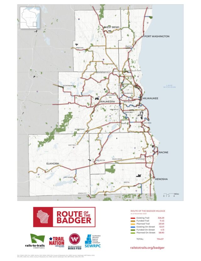
The ROTB map released in 2023 includes over 26 more miles of existing trails than the 2019 map. Planned and existing trails total about 704.6 miles with over 15 miles funded.
- Existing Trail (326.3 miles, 23.2 miles more than 2019)
- Funded Trail (11.4 miles)
- Existing On-Street (52 miles, 3.2 miles more than 2019)
- Funded On-Street (4.13 miles)
- Planned Trail (251.8 miles, 34 miles less than 2019 as planned trails have been completed)
- Planned On-Street (58.9 miles, 3.7 miles less than 2019 as planned on-street routes have been completed)
It takes time to build momentum and produce results for large infrastructure projects when budgets are tight and staff capacity is stretched. Thanks to the dedication and forward thinking of trail planners, nonprofit partners, community members, and government officials, ROTB network mileage is increasing and (as segments are completed) the planned mileage is decreasing. While all of us would like an infusion of cash to have the network be completed tomorrow (and yes, we are working to identify funding possibilities), the key is to keep moving forward and to never give up, slow, steady, purposeful.
Learn more and stay up-to-date on ROTB progress.
Visit the Route of the Badger website!
This article was originally published in the 2024 Bike Fed Ride Guide. All active Bike Fed members receive a print or digital copy each spring. Join/renew today to support cycling in Wisconsin and receive our next issue in 2025!